Week 9 3/6
Introduction
In the Hawaiian resource management system, land was divided and categorized by a complex system of terms. For the purposes of this course, we will concentrate on the three basic divisions. The largest division of land was the mokupuni, or island. Each mokupuni was divided into moku, districts. Each moku was further divided into ahupuaʻa (sub-districts). The ahupuaʻa was the most basic semi-sustainable unit of land, which contained both upland forests and access to the sea. A typical ahupuaʻa was a valley bounded by natural features such as a ridge line or stream. When your residential ahupuaʻa could not provide things you needed, such as a particular plant that grows in wet areas and your ahupuaʻa is in dry, then goods could be exchanged with other ahupuaʻa.
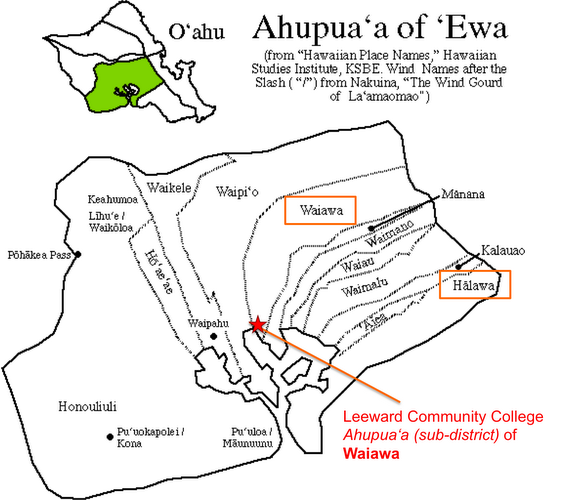
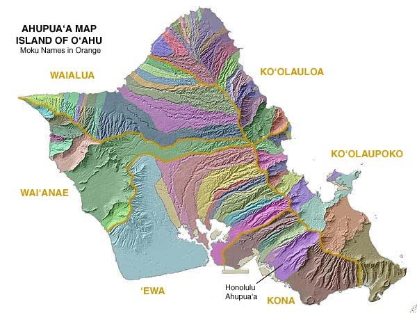
The images below show the six moku of Oʻahu and all of the ahupuaʻa of ʻEwa (in the first image) where Leeward Community College is located and all of the ahupuaʻa of the island (in the second image). The moku of Oʻahu are: ʻEwa, Waiʻānae, Waialua, Koʻolauloa, Koʻolaupoko, and Kona.
In the Hawaiian resource management system, land was divided and categorized by a complex system of terms. For the purposes of this course, we will concentrate on the three basic divisions. The largest division of land was the mokupuni, or island. Each mokupuni was divided into moku, districts. Each moku was further divided into ahupuaʻa (sub-districts). The ahupuaʻa was the most basic semi-sustainable unit of land, which contained both upland forests and access to the sea. A typical ahupuaʻa was a valley bounded by natural features such as a ridge line or stream. When your residential ahupuaʻa could not provide things you needed, such as a particular plant that grows in wet areas and your ahupuaʻa is in dry, then goods could be exchanged with other ahupuaʻa.
The images below show the six moku of Oʻahu and all of the ahupuaʻa of ʻEwa (in the first image) where Leeward Community College is located and all of the ahupuaʻa of the island (in the second image). The moku of Oʻahu are: ʻEwa, Waiʻānae, Waialua, Koʻolauloa, Koʻolaupoko, and Kona.
|
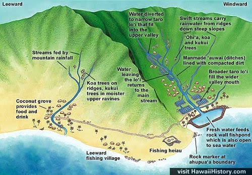
An ahupuaʻa stretches to include the forest and the seashore to ensure everyone has access to resources in these areas--in particular freshwater or wai. Notice in the images below and to the right, that the borders of the ahupuaʻa used environmental features and natural boundaries to define palena, place boundaries. The video clip below describes the ahupuaʻa structure.
|
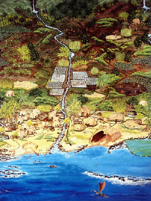
The ahupuaʻa poster above shows some of the various features typically found within an ahupuaʻa--hale, wai, loʻi kalo, mala ʻai, and loko iʻa, for example.
|
|
Wai
Wai, fresh water, is the most important resource; without water nothing grows. The following information describes and examines the use and distribution of wai in Hawaiʻi. |
Kai
Kai, is also an extremely important resource. It is where food is sourced, medicine is gathered, and cultural and spiritual customs are maintained and perpetuated. |
Activities
Due Date
- Read and view all of the information presented on this page.
- Read the article titled, "Hawaiian Cultural and Natural Resource Management" by Davianna McGregor. This reading is found in your Hawaiian Studies textbook on pg. 268.
- Respond to the topic posted in the discussions tool in the Week 9 folder.
- Complete the reading quiz in the tests and quizzes tool titled "Unit2-RQ_ResourceMGT"
Due Date
- Discussion response deadlines are located in the week 9 folder in the discussions tool.
- Answers to the reading quiz, "Unit2-RQ_ResourceMGT" in the tests and quizzes tool are due by Sunday, March 12 at 11:55 pm.
